Android app
Find where to watch the sunset near you, without a mountain in the way
Find my Sun shows which side of a ridge still has a clear view of the sun, so you don't ride or hike to a spot where it vanishes behind the terrain an hour early.


Not the time. The place.
Every sunset app tells you when the sun sets. In the hills and mountains that is not the question: a ridge can hide the sun long before the astronomical sunset, and the valley next door may have a perfectly open horizon.
What matters is which side has a clear view, because that is where the sky lights up. Find my Sun follows the sun's whole descent over the real terrain and colors the map accordingly.
How it works, in three steps
- The map colors the terrainEvery area is shown as a full sunset, a partial one or a blocked view.
- Tap a pointSee what happens to the sun from there and at what time it disappears.
- Read it, then goCheck how reliable the data is and get an estimate of the minutes to get there.
Four states you can read at a glance
Each state has its own color and its own shape, so the map stays readable in direct sunlight and for anyone who has trouble telling colors apart.
Full sunset
The sun stays in view all the way down to the horizon.
Partial
The sun disappears behind the terrain while still high enough to leave a colorful sky.
Blocked
The sun disappears early behind the terrain: don't expect a full sunset.
Insufficient data
There isn't enough data to tell. The app says so instead of guessing.
What you can do with it
-
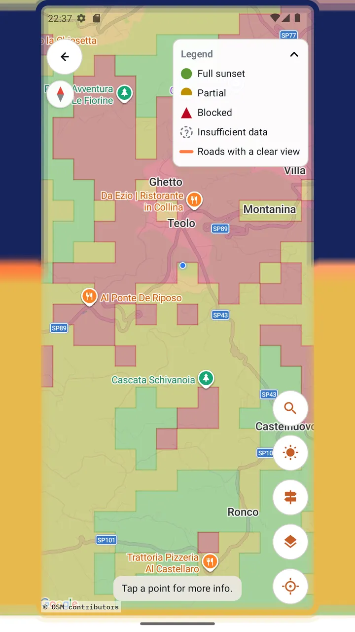
Live sunset heatmap
The map colors the terrain around you by how much of the sunset each area gets, updated as you move and zoom.
-
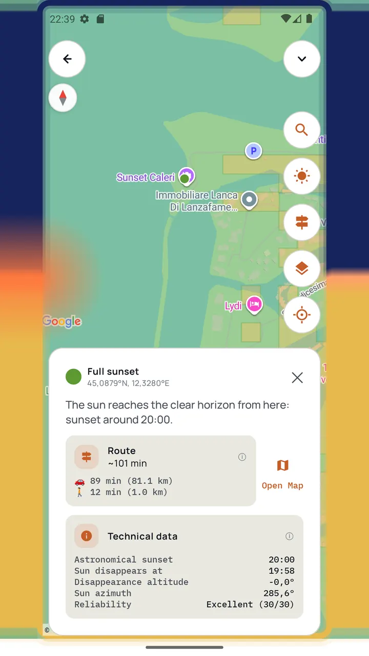
Tap a point, read the details
What happens to the sun from there, the time it disappears, how reliable the data is, plus an estimate of the minutes to get there.
-
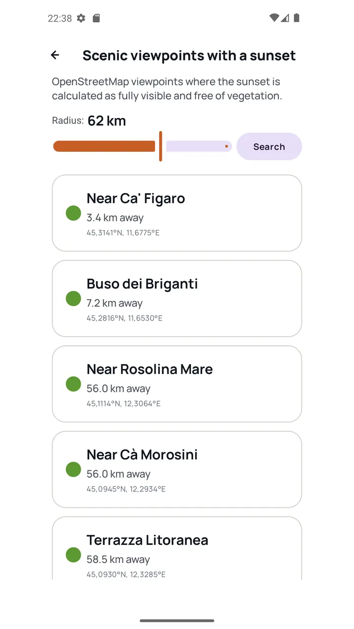
The best spots, as a list
Viewpoints from OpenStreetMap near you where the sunset is calculated as fully visible, sorted by distance. A quick answer when you don't want to explore the map.
-
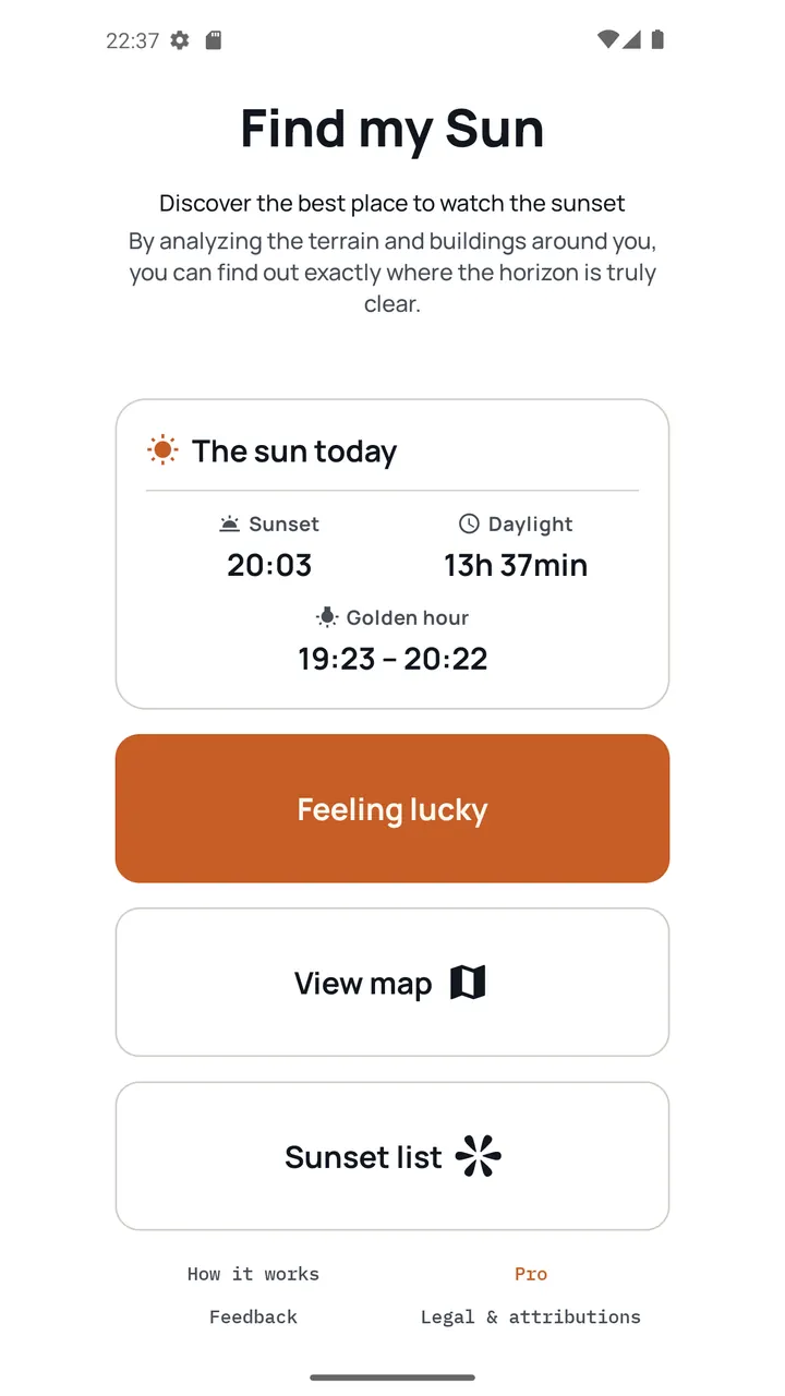
Feeling lucky
One tap finds the best nearby spot on its own, starting from your position. The home screen also shows the sun today: sunset time, daylight and golden hour.
-
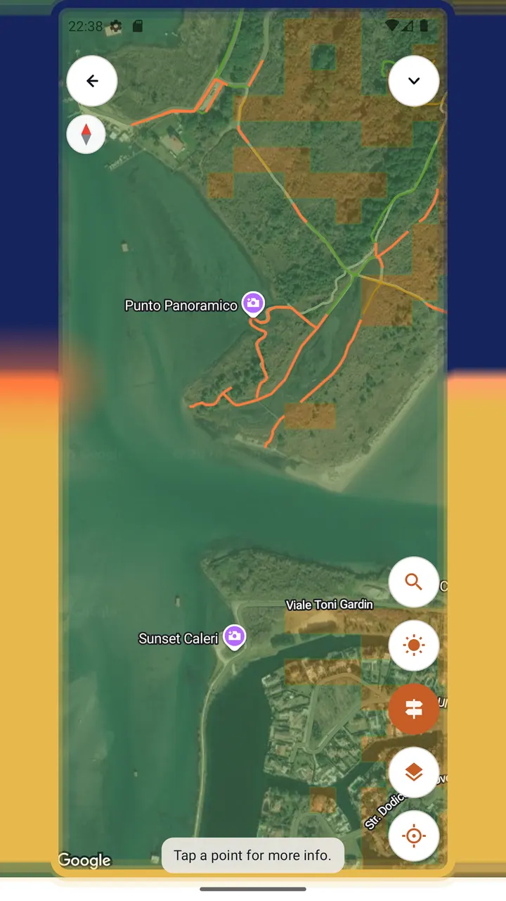
Roads, trails and routing Pro
Roads and paths highlighted in favorable areas, viewpoints too, and in orange those theoretically free of forest. Route to your chosen spot, by car or on foot, with an estimate in minutes.
-
And the rest
A "Best sunsets only" filter to hide everything but the best areas. Place search. Three map styles: OpenStreetMap, Google Maps and satellite.


Who it's for
- MotorcyclistsPlan a sunset stop on a ride, on the side of the valley that will actually have the sun.
- CyclistsPick the climb or the ridge road that still sees the sun at the end of the day.
- HikersChoose the summit or the meadow with a clear western horizon before you set off.
- PhotographersFind the viewpoints where the sun reaches the horizon, or disappears high enough for a colorful sky.
Free, or Pro with a single payment
Find my Sun is free with ads. Pro is a one-time purchase, not a subscription. The price is shown in Google Play.
| Feature | Free | Pro |
|---|---|---|
| Sunset heatmap, point details, sunset list | Included | Included |
| Ads | Banner ads | No ads |
| Place search | 5 searches every 5 minutes | Unlimited |
| Route to a spot, by car or on foot | 3 free previews | Unlimited |
| Roads and trails in favorable areas | Not included | Included |
| Search radius for the list | Limited | Wider |
Under the hood
For readers who want to know how the answer is calculated.
- Terrain data. Elevation comes from the Copernicus GLO-30 Digital Surface Model, at about 30 m resolution. Being a surface model, it includes buildings and vegetation, not just bare ground.
- The whole sun path, not one ray. The sun does not set along a fixed direction: in the Alps its azimuth shifts by 15 to 18 degrees between 12 degrees of altitude and the horizon. The app samples the sun's descent from about 15 degrees of altitude down to the horizon and checks the terrain toward each position. If the view is blocked from the start, the search widens up to 45 degrees.
- Refraction and curvature. The calculation accounts for atmospheric refraction of the sun and for the curvature of the Earth corrected for terrestrial refraction.
- Calculated on your phone. Horizon data is pre-generated and downloaded to the device, and the sunset calculation runs on the phone. That is why the map updates as you pan.
Why the whole sun path matters. In Val Gardena, in the Dolomites, on June 21, a naive single-ray calculation gives a sun disappearance altitude of 1.82 degrees: a high, colorful sunset. Following the whole path shows the sun actually disappears behind the Sassolungo at 29.8 degrees, almost two hours earlier. That case is what the algorithm was built to get right, and it is part of the test suite it is validated against.
Limits
At 30 m resolution a single building or a narrow row of trees can be missed. The app does not consider the weather: it reports terrain visibility, not sky conditions. Estimates near the boundary between categories carry a few minutes of uncertainty, and the field validation is still preliminary.
Frequently asked questions
Does it work everywhere?
Coverage is worldwide. Where elevation data is missing, the map shows "Insufficient data" rather than guessing.
Does it check the weather?
No. It tells you whether a spot has a clear view of the sunset, not whether the sky will be clear that evening.
How accurate is it?
It uses 30 m elevation data and follows the sun's whole descent. Small obstacles, such as a single building or a narrow row of trees, can be missed. Estimates near category boundaries carry a few minutes of uncertainty.
Does it work offline?
No. Find my Sun needs an internet connection to download the terrain data and the map.
What does it cost?
Free with ads. A one-time in-app purchase (Pro) removes ads and unlocks routing, roads and trails, unlimited search and a wider search radius. The price is shown in Google Play.
What data does it collect?
No account is required, and the sunset calculations run on your phone. Location is used on the device to center the map and find nearby spots; it is not stored by us. To work, the app makes technical requests to map, search and routing providers, shows ads through Google AdMob (which may process the device's advertising identifier, subject to consent where required) and reports crashes with Firebase Crashlytics. See the full privacy policy for details.
Is there an iPhone or web version?
Android only for now. A web app is planned.
Data sources and credits
- Elevation data
- produced using Copernicus WorldDEM-30 © DLR e.V. 2010-2014 and © Airbus Defence and Space GmbH 2014-2018 provided under COPERNICUS by the European Union and ESA; all rights reserved
- Map and routing data
- Base map data © OpenStreetMap contributors, available under the Open Database License (ODbL). Vector tiles served by Protomaps. Walking-route calculations use OpenRouteService, © openrouteservice.org by HeiGIT, also built on OpenStreetMap data.
- Open source software
- The sunset math is based on SunCalc, © Volodymyr Agafonkin, BSD 2-Clause License. Map rendering uses MapLibre Native for Android, BSD 2-Clause License. Networking uses OkHttp, © Square, Inc., Apache License 2.0. The app itself is built on Kotlin, Jetpack Compose, kotlinx.coroutines and the Google Play Billing Library, all Apache License 2.0.
Get Find my Sun
Free on Google Play. Built and maintained by Lorenzo Braghetto, a developer and motorcyclist who wanted to know which side of the valley would have the sun.
Questions or feedback? Send feedback, write to lorenzo@lorenzobraghetto.com, or read the privacy policy.
Last updated: 2026-09-19